Locating “Malay Places” and Ethnic Identity Making in Singapore
April 13, 2022

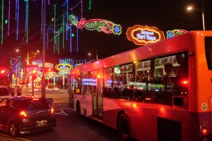
The street light-up for Ramadan and Hari Raya Puasa was first introduced in 1984 by Singapore’s Tourism Task Force. Now an annual affair, the light-up takes place for around a month from April to May at the Geylang Serai precinct, one of the most prominent ‘Malay places’ in Singapore.
In ‘Locating “Malay Places” and Ethnic Identity Making in Singapore’ (Beyond Bicentennial: Perspectives on Malays, 2020) Assistant Professor Hamzah Muzaini (NUS Department of Southeast Asian Studies) highlights four areas in Singapore that have played key roles in helping the Malay community manifest its sense of ethnic identity, from colonial times to the present – Kampong Glam, Geylang Serai, Telok Blangah, and Kallang.
Asst Prof Hamzah argues that every “place” embodies a physical, social, and symbolic dimension. The symbolic dimension refers to meanings attached to places to connect them with the individual or collective self. This is why we experience disorientation when the places we are emotionally invested in dramatically change.
Following independence in 1965, many Malay settlers staying in Telok Blangah were forced to move out of their villages due to the HDB resettlement programme. The HDB ethnic quota system then transformed Telok Blangah from a largely Malay area to a much more multi-racial one.
The name Kallang alludes to an Orang Laut community, the Biduanda Kallang, numbering around 500 around the arrival of Sir Stamford Raffles, who lived near where Kallang River is today. Today, many from the Orang Laut community are no longer distinguishable from other Singaporeans. The Kallang area was also associated with the Bugis, a subset of the Malay community in Singapore. Kampong Bugis in Kallang was an area spanning Kampong Glam to the Rochor River. Today, nothing remains of the original Bugis Town that was located in Kallang.
Following the arrival of the British, Kampong Glam was designated as the ethnic enclave for the Malay community. It was the colonial heart of the Malays, given the presence of the Istana and Sultan Mosque, and its Malay-Muslim inhabitants. For many years, Kampong Glam remained an important focal point for the Malay-Muslims in Singapore. However, over the years, Kampong Glam saw urban renewal processes erasing streets and buildings, and many residents moving out to HDB estates. In 1983, the Urban Redevelopment Authority (URA) designated Kampong Glam as a conserved area. By then, however, Kampong Glam had become a pale comparison from what it was before, and a “ghost town” for much of the early 2000s.
During the Ramadan and Eidul Fitri festivals, Malay Singaporeans prefer Geylang Serai over Kampong Glam, as many Malays perceive Kampong Glam to be a “tourist trap”. Kampong Melayu, better known as Geylang Serai today, was specially designated for resettled Malays in 1928 to continue their traditional way of life. In the 1960s, Geylang Serai was transformed into the first public housing estate in the east of Singapore. Within these blocks was Pasar Geylang Serai, known as the “Malay emporium of Singapore”. It was demolished to make way for urban redevelopment in the 2000s, much to the discontent of the community. There were attempts to highlight the history of the area as a Malay place after the loss of the old market and blocks through story panels and roads named after significant Malay individuals. However, these efforts reaped little fruit.
There is not much left of the traces of the Malays in places like Telok Blangah and Kallang. Kampong Glam and Geylang Serai, on the other hand, have been designated as “Malay places” by the state, and thus tend to be more prominent in the minds of Malay-Muslim Singaporeans today.
Asst Prof Hamzah also noted that as a multi-racial society, there can also no longer be places reserved for just one particular ethnic group to use. In Kampong Glam, while most of the shops still cater to the Malay community, non-Malay businesses have also taken root.
Read the chapter here.
