Uncovering hidden stories of the pre-war Japanese community in Singapore
May 23, 2025
Singapore is home to cultural neighbourhoods such as Little India, Chinatown, Kampong Glam and the area around Tanjong Pagar that has become affectionately known as ‘Koreatown’. But did you know that there was once a ‘Little Japan’ too?
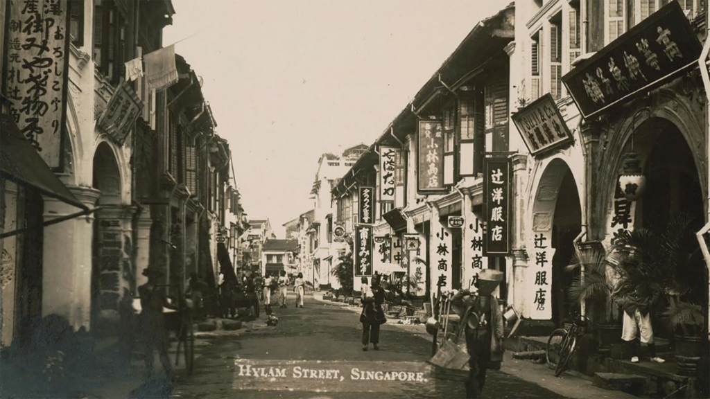
‘Little Japan’ was an area around Middle Road – part of what we know as Bugis today – that comprised businesses, schools and places of worship for a Japanese community that settled in Singapore in the 1800s and 1900s. A community of thousands, they were far from little. Their presence in pre-war Singapore was significant in shaping Singapore’s identity as a cosmopolitan port city in the colonial period.
Dr Clay Eaton, historian and lecturer in the NUS Department of Japanese Studies and Associate at the NUS Asia Research Institute’s (ARI’s) Inter-Asia Engagement cluster, said, “The Japanese wartime occupation of Singapore is well-known to many of us, but Japan and Singapore’s relationship predates World War II. The unique role that the Japanese played here, as representatives of a major imperial power as well as a part of the broader Asian community, can help us better appreciate Singapore’s rich cultural past. Very little work has been done on this community, especially in English, but they can tell us quite a bit about the social complexity of this period.”
In an attempt to reconstruct the pre-war Japanese community in Singapore’s “Little Japan” around Middle Road, Dr Eaton; Professor Naoko Shimazu, also an Associate at ARI’s Inter-Asia Engagements Cluster and former Research Cluster Leader; and Dr Chee Keng Lee from NUS College teamed up for a project known as ‘Mapping Middle Road’, the first public history project of its kind about the Japanese community in Singapore.
The project was carried out under the National Heritage Board’s (NHB) Heritage Research Grant and was hosted by ARI. It took two years to complete and was published as a story map for the National Library Board’s Curiocity[1]. Mapping these historical findings allows users to better visualise how past movements of the Japanese communities around Middle Road unfolded and changed with significant events, thus turning abstract historical change into something we can see and trace across a real-world landscape.
The findings in ‘Mapping Middle Road’ were widely discussed at conferences and talks in Asia and Europe.
The researchers’ findings were also further expanded and later developed into an online resource named ‘Middle Road: Pre-War Japanese Community in Singapore’ that is accessible to the public at MUSE, NHB’s digital heritage publication hosted on Roots.
Bringing the Japanese community’s shifting past to life through maps and movement
Developing this digital map to help users see not only where events and communities existed, but also how they shifted over time, was no easy task.
A team of faculty and student researchers combed through resources such as photos, advertisements, newspaper articles, travelogues and guides in various English- and Japanese-language materials residing in the National Library’s NewspaperSG online archive, the Japanese Association of Singapore’s collections, and the National Diet Library (the national library of Japan); to locate specific references to the Japanese community associated with particular places in the country.
They identified over 20 locations and institutions to feature in the story map, with their efforts culminating in the visual reconstruction of the presence and movement of various Japanese institutions over time. These included schools, clinics, places of worship and businesses – all of which together help us imagine what life was like for the Japanese community here in Singapore at that time.
Dr Eaton shared, “Perhaps our biggest surprise, since this was a mapping project, was how mobile some of the institutions we were tracking ended up being. Just about every prominent business moved at least once (like the clothier Ebisuya) or had multiple branch locations (like the Tamagawa restaurant).”
Important locations such as the Japanese Consulate, Japanese Association and Toyo Hotel moved multiple times, making it challenging to pinpoint their locations onto a map, Dr Eaton shared. Ultimately, the team embraced the shifts in locations as a key factor in explaining the changes within the community over time.
The Consulate’s move from its original location on Sophia Road – located near the Japanese resident community along Middle Road – to the ‘Gudan’ district (the Japanese term for the Central Business District) came as Japan rose in political power globally. Its eventual return to quieter offices on Mt Emily before World War II presumably symbolised the growing isolation of the Japanese Empire on the world stage.
Prof Shimazu shared how researchers had also identified a significant class division within Singapore’s pre-war Japanese community, noting tensions between the first Japanese settlers in Singapore in the late 1800s and a more affluent and educated wave of Japanese immigrants who arrived after 1910 and worked in the Gudan district.
The establishment of elite institutions like the Japanese Association and Japanese Club did not help to bridge the gap. The Gudan expatriates played a crucial role in ending licensed Japanese prostitution in 1920, which affected the original Japanese community along Middle Road.
The stories the research team uncovered confirmed what they had initially thought – that the Japanese community was diverse just like any other and was made up of interesting and dynamic individuals who were at times at odds with each other, but at other times, brought together by a shared sense of national belonging.
[1] National Library Board’s Curiocity houses digitised maps, photographs and multimedia content that are combined for users to explore the past and see how it has shaped the present.